Chamonix Valley #1
Chamonix Valley #2
Chamonix Valley #3
Chamonix Valley #5
Chamonix Valley #1
Chamonix Valley #2
Chamonix Valley #3
Chamonix Valley #5
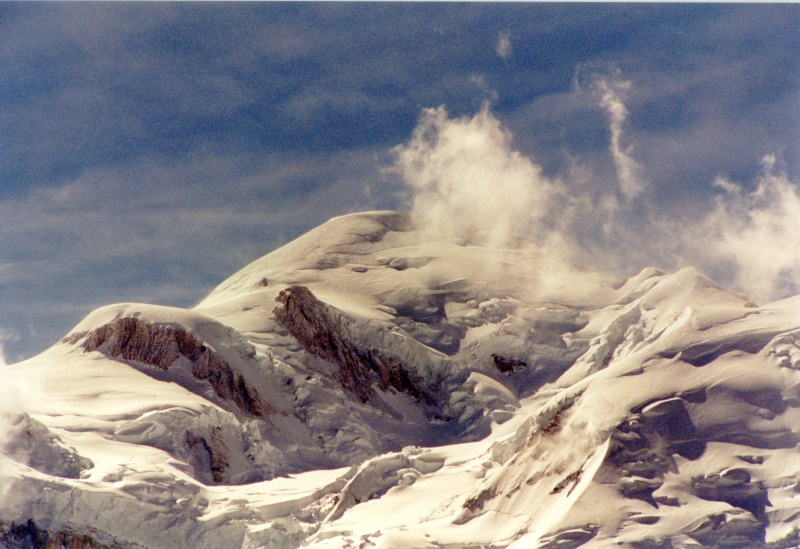
Mt Blanc
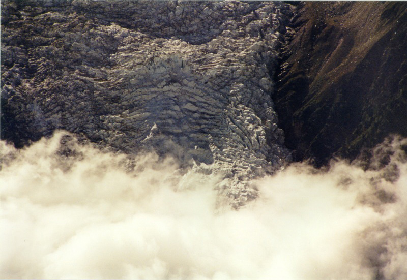
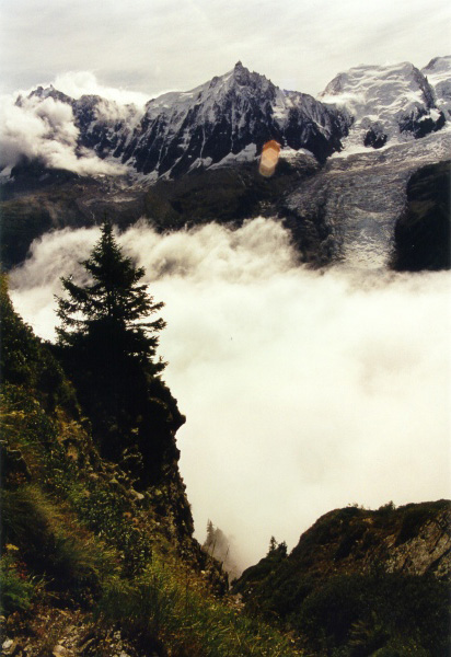
Bossons Glacier
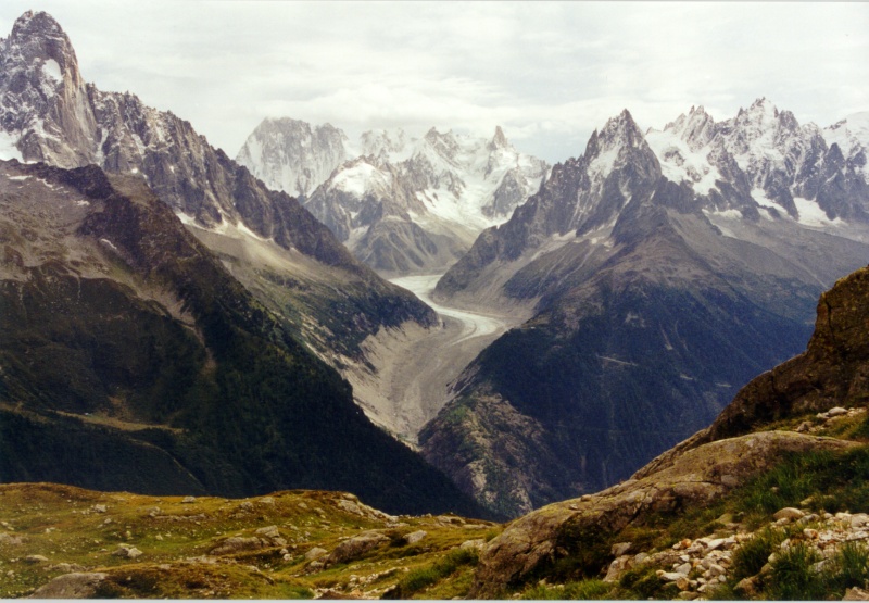
Les Grands Jorasses
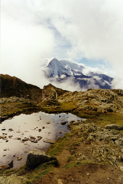
Chamonix Valley #4
I had planned to do some walking in the French Alps but was not sure where to go. You too may want to walk in the high mountains but do not know where to start... read on.
About a week before setting off for France I went back to Paddy Pallins (in Sydney), where I had purchased my hiking boots, to exchange garish shoelaces for timid brown ones. As I tried them for length a guy sitting on the bench was looking through a book. I assumed it was for walks in Australia, but the photos of snow-capped mountains were far too spectacular. It was Harper's book about walking around Mt Blanc. The man told me he had done the Tour of Mont Blanc (TMB) 15 years ago, that it had taken him 7 days, and that it had not been hard.
This immediately gave me the idea to do the same thing. Yet Harper's book said to do the walk in 11 days, so if this man hadn't told me he had done it, without difficulty, in 7, I would not have attempted it. So here I am, telling you that - if you are fit - you too can do it in 7 days, or even less. Of course you can take longer, as most people do. It is not a race. I believe 8-9 days is the normal duration. Don't forget that Harper is writing for the English!
As it turned out, I completed the 186 km circuit in the first 7 days of September 2000, without recourse to buses or cable cars. Nor did I reach the limits of my capacity, though parts of the walk were tough. I carried a light pack (of about 4 kg) and averaged 8 hours' walking per day (not counting stops).
Walking around Mt Blanc is not to be confused with climbing it. The route I took reached its highest point at just 2665 m, though if you take the side-trip to Cabane du Trient you will hit 3170 m.
The bible for English-speaking walkers is "Tour of Mont Blanc" by Andrew Harper, Cicerone Press. If you want to do the tour then do buy this book (no, I don't get royalties). I saw it on sale in Chamonix - more cheaply than in Sydney. Other books are available in French and Italian. You don't really need the book, but it is a big help, mainly for planning the walk, especially if you do so on a daily basis, as I did. Once you are on the actual route you should not get lost, as sign-posting is mainly very good. You may need to order the book in, as my friend at Paddy Pallins had done. Fortunately for me, they had brought in two copies. This was the second chance event that determined my fate, for I would not have gone without the book.
I also recommend buying "Mont Blanc en Liberte", a book with Kompass map included ($13), and/or "Pays du Mont Blanc" map 8 by Didier Richard ($15). To the best of my knowledge no single small-scale map shows the entire TMB. Even these two maps together do not show the entire route. You can get both in Chamonix and probably also in Courmayeur. The maps are not necessary, but they do help and give a feeling of security. A compass is optional - I used mine once.
However, as in all scripture, there are errors in Harper's book. I mention them in my account, below. Remember that there is not a single TMB, as there are alternative routes, such as the ridge route, or the path through the valley in various places. Mostly it is the Grande Routiere 5, so if you see "GR5" you are going the right way.
Although no-one can guarantee you a superb holiday, the TMB features some of the best mountain scenery in Europe. Provided you stay healthy and have good weather you should have a memorable and pleasant time. Be warned, however, parts of the tour are a hard slog. There are long uphill sections that seem like they will not end. If you don't get puffed on some parts of the walk... then you're not doing it right. The French say that a day's walking brings a week of health. Thus the TMB offers some two months' of well-being. No gain without a little strain.
As Harper points out, "The Tour of Mont Blanc is one of the best - if not the best - of the world's classic walks... it has all the excitement of the high mountains yet none of the worry of altitude sickness." Food and accommodation are easily available, though you do need to plan each day, to make sure you are within reach of a lodging by nightfall. There is no need to book (I didn't), except perhaps, in high season. An added inducement is that you walk through three different countries - France, Italy and Switzerland, since the track circumnavigates Mt Dolent, where the three borders meet at a point.
You need not do the entire circuit, though I strongly recommend that you do. You can instead do three-quarters, half or less. For instance, you can return from Courmayeur to Chamonix by bus or cable car.
Should you get fit before you go? Sadly, yes. Unless you want to experience strained muscles, exhaustion and frustration at walking slowly, I recommend building up a reasonable level of fitness before you go. You should be able to walk up to, say, the seventh floor of a building (yes, some buildings still have stairs) without feeling puffed. You should be able to walk upwards at about 300 m per hour, this translates to about 75 storeys per hour, or more practically, 19 storeys in 15 minutes.
Since I play vigorous sport three times a week I had no fears about being fit for the TMB. As it turned out, I felt cramps for about 5 minutes half-way through the first day, but after that brief episode, none of my muscles protested in any way. Yet I had done only a single day-walk in the preceding months.
Though fitness is a strong plus, age is not a barrier. I think I saw more people in their 40s and 50s on the TMB than I did younger ones. It seems that many people rediscover walking later in life, or continue doing it all through. The TMB was only the second long-distance walk I have ever done, the first being 16 years ago. Yet I am all of 48, and my knees are not in great shape, due to a lifetime soccer habit.
When walking it is best to keep a steady pace, rather than going fast and then needing to rest. Beware of walking fast downhill! This puts great stress on the knees. I made this mistake and paid for it. Afterwards I found I could walk much faster uphill than downhill because I had compacted the cartilage in my knees. It is preferable to take five minute rests every forty minutes or so than to make longer but less frequent stops. It is better to walk slowly but without a break than to walk faster and take long breaks. Find the steady rhythm that is right for you.
A word about weight, and I don't mean your thighs. Take the absolute minimum you can manage with. Do not take anything you can do without. Be ruthless and you will thank yourself for it. You don't need spare shoes, spare shorts, clothes to wear at the refuge, nor a torch. There is nothing wrong with wearing the same shirt for a week. Nearly everyone on the TMB carried a pack two or three times heavier than my small four kilo one. You may be able to walk for 6 hours carrying 20 kilos, but imagine how much pleasanter it would be to carry 5 kg. It is no fun being a pack animal for ten days. I did this once and resolved never to do it again. If there is a single mistake that walkers make, it is to carry far too much. I picked up some other walkers' backpacks on the TMB and found I could barely lift them. Don't carry a tent or sleeping bag unless the extra freedom is important to you.
People do the TMB in groups, couples, singles. I met quite a few people on the trail, though hardly anyone after about 4 pm. The route is not crowded in early September. You can have solitude, at times, if that is what you are after.
I walked the route alone and am happy I did so. There are benefits to solitude. It is enjoyable to be completely self-directed, not having to compromise or discuss options with anyone else. There is a feeling of freedom in being able to decide, on the spur of the moment, how far you want to walk, when to start and stop, or where you will sleep on the day. There is a pleasure in self-reliance. You also learn a bit about yourself. You need not fear - if you break your ankle someone will soon find you. Parts of the walk are through wilderness areas but the track is never dangerous. Except for the ladders on the way to Lac Blanc you never need to use your hands (unless you speak to an Italian on the way). I am not very good at following paths yet I did not get lost (except for a few minutes at a time) and neither will you.
So if you like your own company then you'll be fine doing the TMB by yourself. You can always team up with someone if you change your mind during the walk. However, if you want to walk with a "local" you could try writing to the French Alpine Club. I did this last year with its Italian equivalent (CAI) and was very happy with the results - I walked with two Italians on separate occasions.
Following Harper, I recommend starting from Les Houches, the lowest and least spectacular part of the circuit. If you are strapped for time, or feel like a bit of a challenge, you may want to do the TMB in 7 days. If so, you can follow my itinerary, knowing you have a place to sleep (except that the refuge at Balme shut down for 3 months on about September 10). It is also good to know what an actual walker did, though bear in mind that I walk faster than most people, especially uphill (370 m per hour). No-one carrying a pack passed me walking uphill during the 7 days, whereas I overtook many people.
According to Harper, the best time to go is between 20 August and 15 September. The weather is fairly reliable, the snow has melted and the crowds have gone. I did not walk on snow at all, though there were occasional patches near the track. I missed seeing more snow, but the substance is not nice to walk on - especially across a slope.
I never found out what that turn-off was supposed to be. Later Harper writes to turn right for Col de Tricot, whereas it is actually a left turn (follow the sign). So the book is not to be trusted too much - waymarking should take precedence. Coming up to the first pass, Col de Tricot, I encountered bilberries for the first time. Very tasty. I had lunch at the pass, enjoying a view of a glacier and the hamlet 500m below. I heard marmots. Harper writes that it takes all of 70 minutes to get down to Tricot. It looked like a 45 minute job to me. So here I made my first and worst mistake of the TMB. I walked down very fast, in half the time quoted by Harper. I was to suffer the after-effects for the rest of the tour, as the cartilage in my knees became compacted, which subsequently made all non-gradual descents painful.
I passed through the village of Contamines and finally set down at the Chalet de Nant Borrant at 5 pm. I sat outside admiring the view and wrote: "It is 5.45, I am sitting watching the 180 degree mountain panorama at a table in front of my refuge. Only 2 shacks and one car are visible signs of civilisation. The stream is rushing, the crickets are chirping as the day wanes. I am tired but very glad I decided to stay here, not in Contamines. It is peaceful. A little bit of paradise here, with beautiful flowers, including the spherical blue thistles I love. Bees and small butterflies are making the most of the vanishing summer. I am content. There is nowhere else I would rather be. It is also nice there is not a thing I need to do. I didn't enjoy most of today (parts yes) because I was pushing myself."
I was the only guest at the refuge except for a tour of 23 French people who had two guides with them. Funnily enough, they all slept in one room, I in another. The host seated me at a table apart from the tour, but a friendly lady at the big table suggested I join them, which I gladly did.
The next day I set out at about 8, feeling free and fresh. Not a sore muscle or person to be seen, though I heard the beef gamelan. I saw snow in the distance and heard the piercing cries of marmots. As I reached 2329 m visibility was down to 50 m, so I was very careful not to lose the path. The thought of soon walking into Italy raised my spirits. Only a small cube of granite marked the actual border at the windy pass, from which Mont Blanc is visible. At 4.30 I reached the Elisabetta refuge in Italy. The wind was 40-50 km per hour and since the refuge is at 2195 m, walking to the nearby glacier was not a pleasant prospect. Literally five metres from the refuge I twisted my ankle on loose rock. Luckily it came good quickly. In the refuge I ordered an alcoholic punch and this knocked me out. It was nice to speak Italian again, rather than French. Half the refuge was closed for renovation - in fact I thought it might all be closed when I arrived. For a while it looked like I would need to sleep in their tent, but instead I was given the place of someone who hadn't arrived.
Next morning I set off, walking for a while on the dirt road. It began to drizzle and a perfect rainbow spanned the valley. I photographed it and tried to change films, not realising it had not rewound. So I lost most of the film and could not take any more photos till Courmayeur, where I hoped to reach a camera shop before the siesta closed it down. I took the camera incident as a lesson to teach me to not be so caught up in photographing things, but to just experience them. I reached the Miage glacier and went on a detour to see the actual glacier, but it had retreated into the distance. As compensation I saw marmots. Where the path left the road sat a softly-spoken Englishman I had met at Elisabetta. I picked up his pack and said, "If I had to carry that I would just sit down and cry." I really pushed myself to get to Courmayeur quickly, the track being mostly down. Presently I heard what sounded like loud gunshots but it seemed to be an avalanche on the Mt Blanc massif.
I did manage to have my camera fixed (for free) and bought a knee brace, which did not help me. I also had a delicious lunch (in La Terrazza, I think), my best meal on the TMB. Courmayeur is smaller and more attractive than Chamonix. I wasted some time trying to find a place to send an email but eventually gave up due to lack of time. The wine and fulsome meal did not help me as I started the tiring ascent to Rifugio Bertone, rather late, at 2.30. It was also very warm. I plodded into the Bertone at 4 pm, wondering whether I should stay there or continue on to Lavachey, another 14 km. I decided to keep going, despite the scenic location of the refuge and the lateness of the hour. Unfortunately clouds hid the tops of the Mt Blanc massif, so I never really saw it from the Italian side. After Col Sapin pass the arrow for the TMB sent me climbing again. This did not seem right since it should have been all downhill. Realising I was not following the right path, I studied the map and Harper's description, which I had neglected for a while. I retraced my steps and turned down the valley to follow the tiny stream. The path was hardly visible, unlike the main one going up, so I was concerned I was going the wrong way. I had seen cows going home in the distance and decided to follow them. Eventually I caught sight of them and then reached the shepherd. He assured me I was going the right way. Yet the path obstinately headed right, across the mountain, rather than down into the main valley where the town should be. Eventually I did reach the road and then the small settlement of Lavachey with its lone hotel. It was just after eight and getting dark. I was very tired though I could have walked further if I had had to.
The next morning I had the first shower for three days. The walk began pleasantly along the road, where I met a sympatico working dog and picked some raspberries (highly recommended). The road soon petered out and the climb to the pass leading to Switzerland began. As I reached the top I not only had no views but it was snowing lightly. As I penetrated further into Switzerland the scenery became more pastoral. The houses were pretty, too pretty if anything. At 4 pm I reached Praz de Fort, where I planned to spend the night. Unfortunately I learned that the lone hotel mentioned by Harper had closed two years ago due to the owner's illness. I decided to press on to Champex. I saw squirrels along the forest path. Champex is a resort on a lake, even featuring doggy-bag dispensers along the shore.
After an argument with my landlady, who refused to accept French currency unless she could charge me 50% extra, I was off, headed for another high pass. At the top there was a view into a new valley plus a glacier nearby on the left. There were many delicious raspberries on the subsequent descent. On the final leg towards Col de Balme there were masses of bilberries. You can tell them apart from other, poisonous berries, by their characteristic navels. I arrived at the refuge, which is about 100 metres from the French border, feeling worn out. The vista of the Chamonix valley, which I had not seen for some days, now opened out again. Wonderful view (see the cover of Harper's book).
At the refuge there were three Germans, a Dutchman and the nice German couple I had met already three times before. The German guys were doing almost the same circuit as me, except on bikes. It took them six days. I think they said they did it all on the bikes and no-one fell off anywhere. I marvelled at their endurance, for which they had trained for months. The urbane Dutchman acted as interpreter, being at home in French, English and German, as well as a few other languages.
The next morning I descended into French cow pastures, where a curious bovine came so close to me that I touched its snout. Since I was slowed down both by my knees and bilberry collecting, the German couple caught up with me and we walked together for about an hour until a village where we had lunch. I continued alone to La Flegere via Lac Blanc, which is neither white nor a lake, but does possess a wonderful view of the main range on the other side of the valley.
The last day offered the most spectacular views, especially since the clouds and mists came and went, changing the scene in a matter of seconds. The final descent of 1545 m to Les Houches was by far the hardest part of the TMB for me. I was dragging my right leg painfully by the end. What struck me as I re-entered civilisation is how noisy it is.
I wanted to have the feeling of doing it entirely on my own steam, but this sort of ego stuff may not be important to you. Don't forget that days are long. In early September - an excellent time - it gets dark at about 8.30 pm. If you go earlier then the days will be even longer.
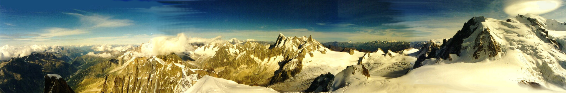
I recommend staying at Chamonix. It is a good place for provisions, maps and sight-seeing. It is not expensive - I paid $68 AUS for a room with breakfast. A strong inducement is that if visibility is OK then you can go up to the Aiguille du Midi (3,840 m) by cable car. It is expensive ($50) but well worth it. Make sure you rug up, as it is about 30 degrees Celsius colder than Chamonix.
On the walk I slept four times in dormitories and twice in hotels. I quote some prices to give an idea. Food on the TMB is generally mediocre. I recommend leaving your main luggage in your Chamonix hotel and taking the train to Les Houches (15 minutes) to begin the TMB early in the morning. Harper recommends staying in Les Houches, which is an equally good idea and allows you to start earlier.
What should you take? Sunglasses, block-out, hat, raincoat, camera, jumper, parka. Stretch denim jeans are fine. No-one ever died of over-heating in the mountains, so take heavy rather than light clothes. Don't forget that it can snow in mid-summer and that mountain weather is inherently unstable.
I recommend buying a bar or two of "1848 Noir" made by Poulain. It is a high-octane chocolate bar, so if you like milk chocolate this is definitely not for you. I carried no other food except for lunch on the first day (unnecessarily). Unless you are a diabetic there is no need to carry food. At the worst you will have a late lunch one day.
Drink all the water you can at refuges, bars, stand-pipes and high streams (above 2,000 metres) - which are fairly frequent. This will save you carrying more than a small quantity (say a 1/2 litre) of water. Miraculously, water, though normally heavy, weighs nothing in the stomach. I carried about a 1/4 litre most of the time.
You can only send email from Chamonix or Courmayeur. There are few shops elsewhere on the TMB. Accommodation is in refuges, high-altitude dormitory-style hotels, or ordinary hotels in small towns. When you get thirsty buy a litre of juice at the grocer's for the same price as a glass at the bar. Where to get food? Bars, refuges.
Day 1 was a departure at 8 am from Les Houches railway station (980 m). Col de Voza (1653 m) at 10.15. Col de Tricot (2120 m) at 12.30. Contamines 3 pm. Nant Borrant refuge (1457 m) at 5 pm. Total of 24 km. Price: $43 for dinner, wine, breakfast, dormitory bed, shower.
Day 2 departed from Nant Borrant at 7.45. Col du Bonhomme (2329 m) at 10 am. Col des Fours (2665 m) at 11 am. Col de la Seigne (2516 m), the Italian border, at 3.30. Rifugio Elisabetta (2195 m) at 4.30. Total 29 km. Price: $50 for dinner, wine, breakfast, dormitory bed, (shower was extra).
Day 3 left Elisabetta at 7.45, reaching Courmayeur (1220m) at noon (I was in a rush as I had to repair my camera before the onset of siesta). Courmayeur is the only real town with shops and other facilities on the TMB. It is also pretty - more so than Chamonix. I left at 2.30 - rather late. Rifugio Bertone (1991 m) at 4.15. Col Sapin (2436 m) at 6.15. Arrival at 8 pm at Lavachey as it was getting dark. Total 40 km. Very tired.
Day 4 left Lavachey at 8.15. Grand col Ferret (2537 m), the Swiss border, at 10.30. La Fouly 2 pm. Praz de Fort at 4, where the hotel had closed, so I had to go on. Arrived in Champex at 6.15. Total 36 km. Price: $55 for own room, breakfast, shower.
Day 5 left Champex at 8.45. Arrived at Fenetre d'Arpette (2665 m) after a tough climb at 11.30. I decided to skip Forclaz and continued to Les Grands at 4.15. Reached the French border, Col de Balme (2191 m), at 6.15. Total 20 km.
Day 6 left Balme at 7.45. Arrived at Trelechamp (1400 m) at 11.45. I reached Lac Blanc (2352 m) at 3.30. La Flegere (1877 m) at 5 pm. Total 19 km.
Day 7 left La Flegere at 8.30. La Brevent (2525 m) at 10.45. My knee was quite bad so I limped painfully down 1545 metres to reach Les Houches at 3 pm. Total 18 km. I was back in Chamonix before 4, giving me time to go up to the Aiguille du Midi. This was inspiring - please click below.
Please send feedback, complaints, questions, suggestions to "soler@soler 7.com" - this email address has an extra space - please remove it if you want to email me. I have used this little trick to avoid being targeted by automated spammers, as opposed to nice people like you.
Mountain Home
Home
This page was created on 28 September 2001, last updated 22 October 2008.